volume
25/01/2016
•
123 cm

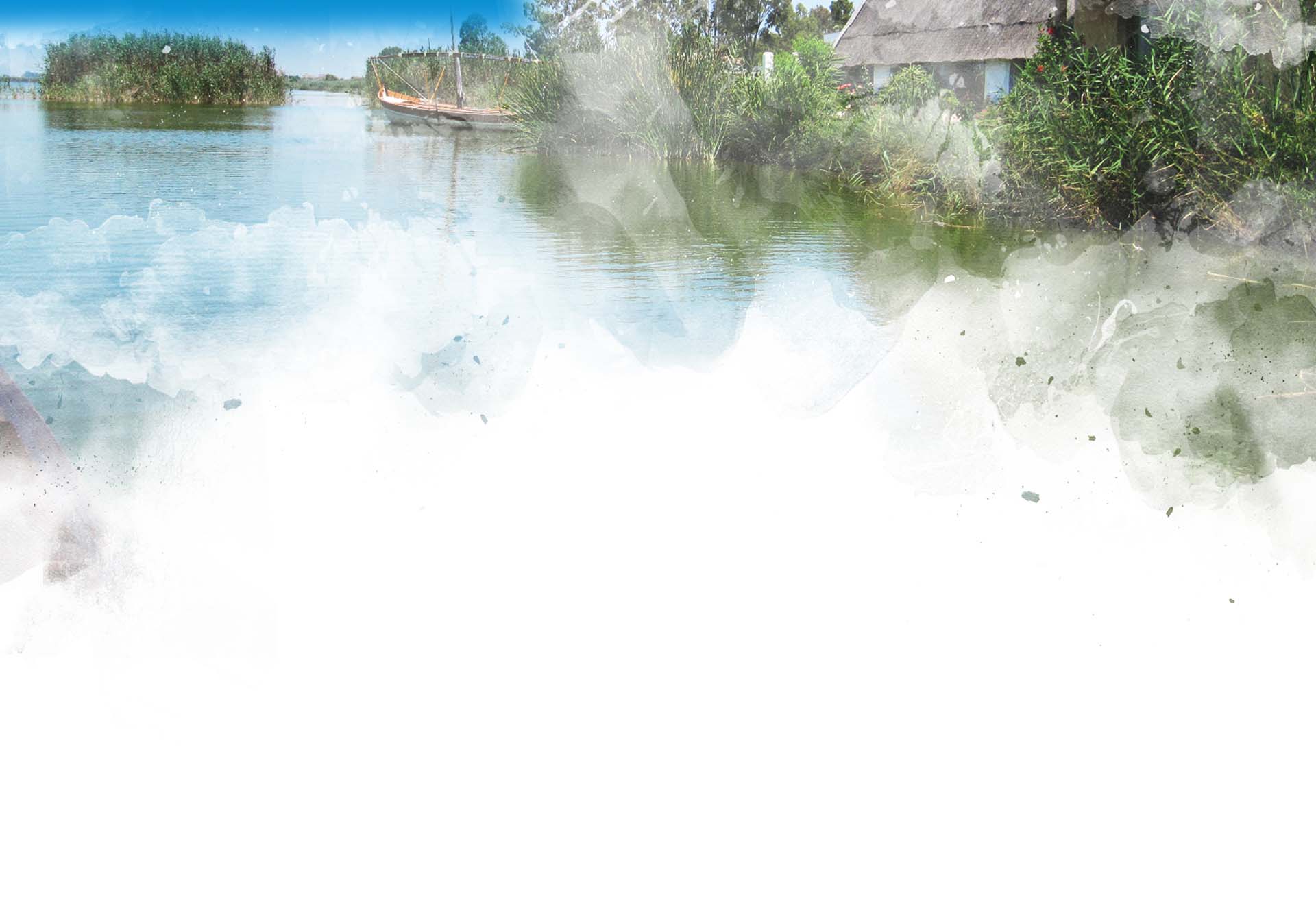
Natural Parks are sustainability laboratories where people study and implement strategies in order to harmonise human activities with conservation of natural assets. An example of an environment where nature and human activity coexist in a common space is l'Albufera de Valencia Natural Park.
When we imagine a National Park, we think of a predominantly wild area with minimal human presence. On the other hand, the concept of Natural Park combines many other aspects. This is especially so when we speak of l'Albufera de Valencia Natural Park. Various activities have taken place in this environment for centuries. Its current status is to a great extent the result of the transformations caused by generations of residents as they exploited the land to generate an income from its resources (salt extraction, wood and timber, game, fishing, rice farming...). Those transformations created a sustainable system of coexistence between residents and their environment.
At present, in addition to these traditional forms of exploitation, many others have appeared which makes compatibility with conservation of eco-systems difficult.
The increase in these modern human activities that affect the conservation of the Natural Park poses a challenge which requires careful management, analysis, regulation, investment, and decisions to be made... The protection of valuable eco-systems in this area entails restrictions of certain forms of exploitation and certain limitations... however, it also creates opportunities for new forms of development.
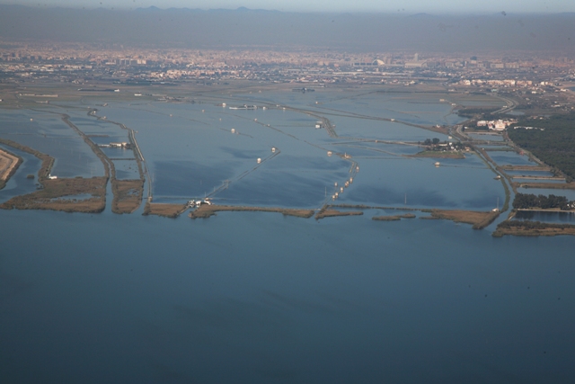
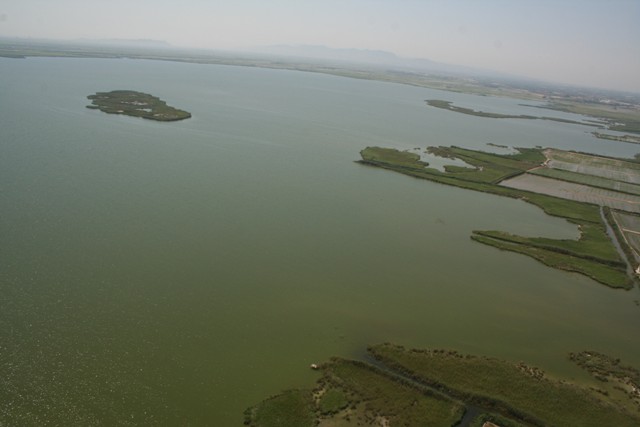
The lake of l’Albufera is one of the most valuable eco-systems out of all the elements within the Natural Park as a whole. Its waters attract numerous birds to l'Albufera, making it their chosen place for feeding, resting and breeding. However, its ecological condition is a far cry from its condition a few decades ago. In the 1960's, before urban development began in the metropolitan area of Valencia, its waters were clear (fishermen used to drink it directly from the lake in parts they knew well!), aquatic plants could be seen at the bottom and numerous fish species of different types swam along and across. Water voles and otters, which are renowned for settling only for the cleanest of environments, could be found in l'Albufera as it was an ideal place to live. This agricultural transformation of the area surrounding the lake had changed its status from brackish marsh to a biodiversity haven full of clear freshwater.
However, the inevitable urban, agricultural and industrial development of Valencia and the neighbouring towns generated, in the early 1970's, a rapid degradation of the quality of the water on l’Albufera. Gone were the days when you could see the bottom from the surface. Once the clear waters were gone, so were aquatic plants, most fish species, molluscs, water insects and small mammals affected by the fact that their food chain had been broken.
Nowadays, even though the lake continues to be a great source of biodiversity, its waters are still not clear. Only a couple of fish species, which are highly resistant and able to live in murky waters, continue to live in the lake, and few aquatic plants are able to endure the eutrophication conditions caused by the high concentration of organic matter in the water.
In recent years, the authorities have carried out initiatives towards improving the water treatment systems to treat outlet waters before they reach the lake.
An unfinished business: to ensure that l'Albufera has an ecological water flow in sufficient QUANTITY and of sufficient QUALITY to recover the good ecological condition it had until the 1960's.
Water is, for the complex living system of l'Albufera, like any other wetlands area, a key as well as an essential element. The lake needs sufficient flow in order to support all its living organisms. However, there is less and less good quality water reaching l'Albufera, which compromises its conservation.
The water reaching l'Albufera comes from different sources:
The largest water inflow comes from the Jucar River (both in terms of quality and prevalence) along with the return flows from the Turia River. Historically speaking, these accounted for more than 85% of all inflows into the system. In recent years, these inflows have decreased drastically. Studies released in 2003 and 2004 showed a decrease of more than 75% in the inflows from the Jucar River to the wetlands from 1980 to present.
Up until the early 1960's, the lake, although reduced in size and maintained through a man-made system, showed an extraordinarily high quality of water which supported a wealth of aquatic fauna and flora.
In the 1950's, the construction of the sewage systems in the lakeside towns and the boom that the industrial sector experienced in the metropolitan area of Valencia and other areas of l’Albufera basin poured large amounts of urban sewage and industrial wastewater into the lake, causing an unprecedented water contamination crisis, which resulted largely in the loss of natural populations associated with the water-based environment surrounding the lake and, subsequently, a widespread impoverishment of the eco-system.
In just a few years, the lake rapidly developed a state of extreme eutrophy, which can be explained as an excessive prolipheration of phytoplankton biomass consisting almost exclusively of cyanobacteria (also known as blue-green algae; these are microorganisms that give the water on the lake its characteristic greenish colour) and also a great increase in turbidity, which may prevent light from penetrating but a few centimetres into the surface.
These conditions caused the water-macrophyte-rich meadows, which were unable to harness the sunlight needed in order to perform photosynthesis and germination, having also been affected by the widespread use of phytosanitary products in farming in this area at the time, to deteriorate in a way that, by the early 1970's, they had completely disappeared from the lake.
What is a hyper-eutrophicated lake? A sudden burst of phytoplankton growth (i.e. the microalgae giving water its greenish colour) causes water's pH level to increase since the amount of organic matter in urban and agricultural wastewater increases pH, which turns the nitrogen in water into ammonia compounds that are toxic for the most vulnerable fish. Phytoplankton performs photosynthesis through which it creates organic matter and breathes in oxygen at night. Phytoplankton saturation results in the production of sulphide (by decomposition of large amounts of organic matter) and drops in oxygen concentration at night (thus creating the conditions for anoxia or low oxygen levels for many aquatic organisms that need to breathe, causing the resulting ammonia compounds created to become even more toxic).
Zooplankton is thus displaced by an overwhelming amount of phytoplankton, which is in turn freed from its largest "predator". Lastly, excess phytoplankton increases water turbidity and prevents sunlight from reaching the bottom of the lake, thus hindering the survival of floating aquatic plants which cause the erosion effect of waves against island and shore vegetation to slow down. This loss has severe repercussions for the lake's eco-system. On the one hand, biodiversity in the lake drops sharply. The vast majority of invertebrates depending on aquatic plants disappear together with the plants, and thus all floating organisms they supported. Their numbers dropping to a minimum, in the case of fish species; alternatively, they must find new feeding sites, as is the case of anatidae and coots, the numbers of which are falling sharply.
Highly valuable species such as gambetes (Atyaephyra desmaresti, Dugastella valentina and Palaemonetes zariquieyi), the petxinot (Unio elongatus), endemic Cyprinodontidae fish (Spanish Toothcarp –Aphanius iberus- and the Valencia Toothcarp – Valencia hispanica-), the European seabass or llobarro (Dicentrarchus labrax) and the eel (Anguilla anguilla) can no longer be seen in the lake or have now become rarer species.
In the last few years, the implementation of water treatment plants and sewers has improved the quality of the water, but there is still a long way to go.
When the meadows disappeared, their protective effect also disappeared. This caused the hydrodynamic regime of the sedimentary lake to change radically from a situation where positive sedimentation conditions reigned around the matas (thickets or vegetation clusters on the shores that favour their expansion, to the current situation, in which l’Albufera is dominated by erosion phenomena. The waves pushed by the wind have no barrier for their energy to be dispersed and stop their movement, so the waves break against the shores with all their might, thus removing the fine sediments of the lake and altering its gentle profiles, uprooting plants and destroying thickets, which quickly disintegrate. A study from 1997 concluded that, between 1973 and 1994, the total area covered by thickets of the lake of l’Albufera had decreased by 20%.
Lagoons are systems that evolve with a natural tendency towards silting; however, the speed at which this process occurs may be substantially altered due to human intervention, both in a positive and negative sense.
In the case of l’Albufera de Valencia, setting up all prospective sewage infrastructures, carrying out regular campaigns focused on dredging and essentially, increasing the amount, and especially the quality, of water inflows, would represent key steps towards restoring its good ecological condition and ensuring the long-term conservation of such a unique eco-system.
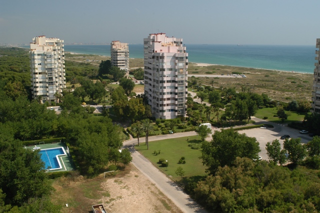
There is something rather disconcerting for those who visit the Natural Park for the first time, having heard about its numerous natural assets: When they come closer to the Devesa forest, through the trees and towering imperiously over them, dozens of buildings impose their presence. These are the most blatant reminder of a historical moment when l'Albufera de Valencia was close to having a change of fate and becoming an extended part of the built-up city. It did not suffer the same fate as other coastal areas and had a narrow escape, although the scars remain.
In the 1950's, the Devesa forest was virtually untouched. Except for the districts of Pinedo and el Saler, and perhaps the odd small building on the coastline, the campsite and the homes of the forest rangers, the rest was full of pine trees, dunes and shrubby vegetation... The residents of the city of Valencia used to have picnics in the forest on a Sunday, parking their cars under the shade of the trees and enjoying a "paella" with their family and perhaps even a little dip on the beach.
In the early 1960's, Valencia City Council following the overall trend of the Spanish Mediterranean coastline, decided to exploit the economic assets of their stretch of coastline. This marked the beginning of an urban development plan for the area that aimed to turn it into a tourist resort and housing development to attract investment and welcome numerous tourists searching for sunny beaches. It proved too high a price to pay: paved roads, tower blocks, the marina, the racecourse and hotels would all be built on top of that forest that the residents of Valencia cherished so much.
The works began and so did tree felling. However, the civil society, even though unaccustomed to participatory processes under the Franco regime, demonstrated vehemently against this Plan that threatened to steal the treasure they had inherited from their grandparents. Organisations, professional associations, university departments, journalists and individual citizens were involved. The newspapers showed, for nearly 10 years, the ongoing controversy between those who wished to maintain the Devesa forest as a Mediterranean forest and those who wished to turn it all into a resort. It was probably the first social movement for the environment in Franco's Spain.
In 1981, Valencia City Council gathered citizen sentiment, halted the building plans for the Devesa forest and redirected its management targets towards the conservation of the area's eco-systems.
From those times, one can still see, in the middle of the forest, 29 blocks of flats (of more than 12 floors), two housing developments, two large hotels, a motorway running between el Saler and the rice fields, a reservoir and a golf course in addition to mile after mile of paved roads, pipeworks and sewage systems, all of which remains unused. Other structures have been turned into something else : The unsuccessful racecourse is now an integral nature reserve as well as an Interpretation Centre for the Natural Park; the promenade was pulled down and dunes and dune slacks regenerated. Stretches of the old roads have been regularly removed, leaving instead access road stretches for fire engines.
In 1962, Valencia City Council authorised the implementation of a Management Plan for Monte de la Devesa, as well as transferring land to the Department of Information and Tourism to build a golf course and the Luis Vives Parador. In 1965, the works on the Parador and golf course were underway when the Department of Housing approved the final version of the Management Plan. The Plan included the construction of motorways, blocks of flats, a promenade, restaurants, housing developments, large hotels, shops, a marina, single-family detached homes, and more.
The Royal Spanish Society of Natural History was the first organisation to publicly show their position against the Plan by stating, in 1966, that they felt “concerned [at the time] more than ever before about the fate of such a unique environment, following the announcement that a series of housing developments have been planned, some of which are of a considerable scale...". This stance was echoed by the School of Science and, in 1970, by Félix Rodríguez, a popular environmental journalist for "la Fuente", who spoke on his television programme, called "Fauna Salvaje" [Wild Fauna], as well as on various forums, of "the sad situation of the Albufera and El Saler". The controversy was underway with newspaper articles where biologists, experts, journalists and politicians spoke for and against the urban development plans for the Devesa forest. It became one of the first of what could be described as a "green" movement in Franco's Spain.
Some defended the construction of buildings by claiming it would give the city of Valencia a boost as a tourist destination, whereas others complained about the loss of a natural treasure that belonged to everyone. While the public debate continued and people's discontent was clear, the plots of land in the Devesa forest were being sold out. In 1973, once the Management Plan had already reduced the area of the Devesa forest down to 70%, the Council decided to commission a new study following the "sentiment of Valencian people". A few months later, the "Saler Re-development Plan" was launched, which stemmed from the new study while remaining of a similar nature to the previous one. Once again, newspapers showed discontent across large sectors of society such as journalists, organisations, citizens and even the Professional Associations of Architects, Doctors, Philosophy Graduates, Humanities and Science, the Trade Athenaeum, the School of Architecture, among others. In addition to the numerous individual complaints that were made against the new Plan, there was a public petition signed by 15,750 people. The motto "El Saler per al poble" was adopted my the majority of people.
In 1976, a third version of the Plan was drafted, yet in 1977 pine trees were still being chopped down in order to build the blocks of flats planned 4 years earlier.
Eventually, in 1978, an interdisciplinary team was commissioned to create a Special Plan for the conservation and improvement of the Devesa-Albufera eco-system. In 1981, with the first democratically elected council authorities, the first signs of change in the management of the Devesa forest could be seen, this time following a more conservationist approach that focused on raising environmental awareness.
The location of l'Albufera Natural Park, just south of a city with more than 800,000 inhabitants, as is Valencia, means that a large number of vehicles regularly circulate through it.
The road called Pista de Silla (roads V-31, E15, A7, AP7) skirts around the western perimeter of the Natural Park, being the main artery to access the regional capital city from the south. The most direct alternative route is the CV500, which runs 27 kilometres north to south across the Natural Park. For over 8 kilometres, this road acts as an impressive barrier between two interdependent biotopes: the Devesa forest to the east, and the lake and its marsh to the west.
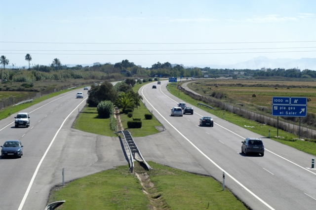
Many animals must cross this road and too many can be seen run over on it. The barrier effect this road has is such that it has even been regarded as one of the roads with the highest animal mortality rates in Spain (according to a Study by the Federation of Groups for the Defence of the Environment – CODA, 1991). The animals that have been worst affected by vehicles running over or hitting them include the mallard, the European rabbit, the genet and several reptile species.
The average daily traffic intensity (ADTI) on the CV500 has been estimated in more than 18,000 vehicles on the motorway stretch, more than 12,000 on the stretch between Saler and el Perelló and more than 9,000 bewteen this area and the south (period 2002-2007).
Those using the motorway could be classed into three groups:
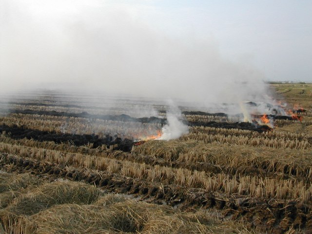
Every year, following the rice harvest in l'Albufera Natural Park, stalk is left lying in the fields. The traditional solution to remove it has always been to burn it while in the rice fields. This has a strong environmental and social impact (as it produces greenhouse gas emissions and causes habitat degradation). The plums of smoke started to appear in the areas surrounding the lake, sparking protests from many local residents from the Natural Park (who complained about having headaches, asthma, rhinitis, or finding their laundry dirty, and their cars covered with ashes…) about the airborne particles released by the burning of stalk. This problem, which has been present worldwide, led to a gradual ban on the burning of stubble at a global scale in the developed world.
There are two alternatives to the burning of rice stalk, which are already carried out in other rice farming areas:
According to a study commissioned to the Mediterranean Centre for Environmental Studies (CEAM in Spanish), the burning of rice stalk in l'Albufera Natural Park could produce emissions equivalent to 2,074,250.47 kg of CO2.
Historically, stalk has always been incinerated in l’Albufera Natural Park without this causing any issues or disturbances. This is due, to a great extent, to the fact that the stalk produced in the fields was exploited for use in stockbreeding, orchards, fuel, construction, etc. Only a part of it was piled up in the fields and burned by farmers.
If at times, stalk was left in some of the fields decaying in the water of the Glossary Link perellonà, this posed no problem given than the water flow was higher that the current one in the water system of l’Albufera. Since the 1980's, there has been a sharp decrease in the water flow from the Jucar and Turia Rivers, which waters the rice fields through irrigation canals and ditches, later reaching the lake and onto the sea. The environmental problems in l'Albufera Natural Park have worsened due to this precarious water balance.
The problematic of rice stalk is also affected by the water shortage. The smaller the quantities of water, the higher the proliferation of issues related to the anaerobic decay of stalk. What constituted perhaps a minor issue in the past, which usually died down, is now blown out of proportion since it occurs in an environment with precarious flows, which are insufficient to clean away any remains of decayed stalk that could be left in the fields.
Every rice farmer in the Natural Park has recourse to the Common Agricultural Policy (PAC) and receives agri-environmental aid packages, which covers approximately the same amount of money they make for selling the rice. The CAP, which in the Autonomous Region of Valencia is implemented through the Rural Development Programme (PDR)compiles a series of agri-environmental regulations such as the “Conservation of wetlands supported by rice farming". Following the application of these agri-environmental regulations from the CAP, a compensation system for wetland farmers has been in place for a few years, in exchange for their compliance with certain restrictions in rice farming practices::
This means that farmers have agreed not to burn rice stalk in order to receive aid packages. Even though this may be the case, the truth is that for many years, stalk has continued to be burnt, under the exception provision contained in previous versions of the PDR.
The latest version of the PDR (2007-2013) contains in section 5.2.1.3.2. the item: “Sustainable rice farming in wetland areas”. In this version, there is a change in the content of the agri-environmental commitments that must be complied with in order to receive the 468.44 euros per hectare that each farmer is entitled to:
TOTAL: 468.44 euros per hectare.
Three aspects must be noted with regards to agri-environmental aid packages as in the new version:
Although the of municipality Valencia accounts for a mere 6% of the territory used for rice farming of l'Albufera Natural Park (952 out of the total 14,100 Hectares of rice fields), in 2001, Valencia City Council decided to take the lead and implement trial measures to solve the environmental dilemma of rice stalk removal, which, although occurring mostly outside the city boundaries, affected its residents nonetheless.
Valencia City Council launched, with the backing of the European Commission, two pilot projects in order to further investigate the effects of the burning of rice stalk. These projects would also try out one of the two options available for rice stalk burning, in addition to deep ploughing; as well as systems for rice stalk collection from small-scale farming fields. Lastly, the recycling of collection stalk for various uses was also reviewed.
Between 2001 and 2007, there were two consecutive illustrative pilot schemes: Biocompost and ECO-RICE, from which three conclusions were drawn:
As indicated by the illustrative nature of the Biocompost and ECO-RICE pilot projects, their aim has been to experiment with alternatives all along and draft conclusions to be delivered to the relevant authorities on agricultural matters, not to provide a final solution to the entire problem of rice stalk burning, an issue that is outside the competence of the local authority. In fact, the competence scope applies only to the rice fields in the municipality of Valencia. Both initiatives were thought to be highly successful by the European Commission, since they met their objectives of shedding light on experimental data to take further steps.
Would you like to know more about the initiatives aimed at finding alternatives to the burning of rice stalk?
-The LIFE Biocompost Project