volume
25/01/2016
•
123 cm

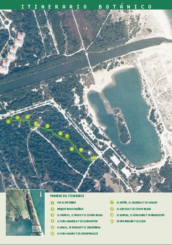
The first reference related to Plà de Na Sanxa (Sancha’s clearing) dates from the end of the 14th century and mentions a woman, Sancha, who was authorised to graze her cattle and goats in this clearing. Later, in the novel “Cañas y barro” by Blasco Ibáñez, there is the legend of “Sancha and the Goatherd”. According to the author, in this clearing there lived a goatherd whose only friend was a small snake that he called Sanxa. Every day he would give her a bowl of milk from his goats, and he would play with her. The people of the place were terrified when they saw Sanxa with the goatherd, and when she wrapped herself around his body. The goatherd had to go to war, as a soldier, and he was away for some years. When he returned, Sanxa had grown considerably and when she saw her friend she wrapped herself around him as before and asphyxiated him.
The characteristic vegetation of the Devesa is the dense Mediterranean scrub known as “maquia”. The term “maquia” (from the Italian “maccia”) is originally a Corsican word which is used to refer to Mediterranean vegetation made up mainly of tall bushes of more than 2.5 metres high and generally hard perennial leaves (sclerophyll). The word “maquis”, used to describe a person who lives a clandestine life, hidden in an area of dense vegetation, has the same origin. The dense scrub, made up of Kermes Oak, Mediterranean Fan Palm, False Olive, Mastic, and Italian Buckthorn, among others, is one of the most interesting and characteristic plant communities of the Devesa. Normally this scrubland is found together with pine forest, usually made up of Aleppo Pine, and to a lesser extent Maritime Pine.
Among the tangle of vegetation that can be seen at this point, the Mediterranean Fan Palm, the Myrtle and the Palestine Buckthorn are particularly worth noting. The Mediterranean Fan Palm (Chamaerops humilis L.), also known here as the margalló, is the only palm that is native to continental Europe. It is usually small but can, in some cases, reach 3 metres high. It has a fibrous trunk, and the heart is eaten in salads, though it cannot be extracted without killing the palm. The Mediterranean Fan Palm produces small round dates, which are not edible for humans, but are eaten by some rodents. For centuries people have used its fan shaped leaves to make objects for domestic use, such as brooms, baskets, hats and bags... From the middle of the 19th century, when the crafts that used the Mediterranean Fan Palm were industrialized, the demand for this plant increased considerably. Currently, with the appearance of synthetic products (plastics) the plant is no longer used for these purposes.
The Myrtle (Myrtus communis L.), also known locally as murta, is an aromatic bush that can grow to up to 5 metres in height. Its leaves are a brilliant green. The white flowers grow from the leaf axils (the joint where the leaves meet the stem). The whole plant is very fragrant and aromatic. The leaves and berries, called “murtones”, are used to prepare an aromatic tonic wine that is very agreeable to the palate. The plant also contains an alcohol, myrtol, with balsamic, antiseptic and sedative properties, and for this reason it has traditionally been used in the treatment of lung and bronchial ailments. Traditionally, the branches are used in many villages to prepare, in fiestas and processions, the so-called “enramades” (a carpet of branches that is spread in the streets to perfume and decorate them).
The Palestine Buckthorn (Rhamnus oleoides L.), also known as arçot, is a bush that can reach 3 metres in height. The berries are round, initially green and later turning black as they ripen. Its stems and branches end in strong thorns. We can sometimes see lizards, grasshoppers or other insects and small reptiles stuck on these thorns. This is because the Woodcht shrike (Lanius senator), a small bird, uses the bush to hold its prey while it eats it, or as a larder (it kills them in times of abundance and stores them for times of scarcity).
At this point the route passes through an area where there used to be a car park, and where pines have now been planted. The Aleppo Pine or White Pine (Pinus halepensis Miil), is the most abundant variety of pine in the Devesa. It has a great capacity to adapt to areas with extreme conditions. It is called the White Pine, because as it gets older its bark turns a whitish colour. It is easy to recognize due to its small needles and because the cones stay on the branches even when they are open and dry. In spring, when it flowers, the male flowers produce a large quantity of pollen. It is therefore very common in that season to see the ground in the Devesa covered in yellow dust, as if it had been dusted with sulphur. The wood is very resinous and hard, so that its use for carpentry is very limited. Its bark is one of the pine barks with most tannins and it has therefore been used to cure leather. Like other pines, it is a source of turpentine, which is used to make white spirit. It is also used to extract aromatic essences to make bath salts.
The Everlasting (Helichrysum stoechas L.), also known locally as mançanilla borda, is a small perennial that grows up to 50 centimetres high and has very narrow leaves. It has a very particular smell and its bright yellow flowers grow in groups. It flowers in spring. The petals, dyed with different colours, are used to create the tapestry of the Virgen de los Desamparados (Our Lady of the Forsaken) each year in May, in the city of Valencia, to celebrate the festival of the patron saint.
Here we can see three shrubs that are also typical of this particular ecosystem. From smaller to larger they are Heather, Albaida and the False Olive. Heather (Erica multiflora L.), also known locally as petorret, is a small shrub which can grow to over a metre in height. It has very small narrow leaves grouped in threes. The pink flowers are grouped at the end of the branches. It flowers in winter and can be seen in the clearings of the scrubland of the Devesa. Due to the beauty of its flowers, it is cultivated as an ornamental shrub. The wood of the root is still used to make pipes and oil lamps.
Albaida (Anthyllis cytisoides L.), also known here as albada or botja blanca, is a shrub with whitish leaves and branches. It flowers in spring. Its yellow flowers form ears at the end of the branches. It is abundant throughout the open scrubland of the Devesa. The False Olive (Phillyrea angustifolia L.), also known locally as the aladern de fulla estreta, is a shrub that can grow over 4 metres in height. It looks very similar to the olive though its leaves are smaller. Its berries, which are small and black when ripe, are food for many birds in the Devesa. It is very common in all low-lying Mediterranean scrubland. It flowers from February to April. The False Olive and the Italian Buckthorn are the species that characterize the maquia of the Devesa, and belong to the Phillyrea-Rhamnetum angustifoliae plant community.
At this point we can see an example of Maritime Pine, together with the spectacular Sarsaparilla which wraps around other shrubs. The Maritime Pine (Pinus pinaster Aiton) is a tree with a pyramid shaped canopy. It has a thick trunk, with rough cracked bark. The pine cones can reach up to 20 centimetres long. The needles can also grow very long, to almost 25 centimetres, and this means that birds do not nest in the tree. The tree was introduced to the Devesa at the start of the 20th century. It has not adapted well to the area which explains its progressive disappearance.
The Sarsaparilla (Smilax aspera L.), also called arítjol or parrilla locally, is a trailing vine with snaking prickly stems. The heart shaped leaves are hard and shiny, sometimes with spiny edges and two tendrils at the base, which the plant uses to climb trees and shrubs. The berries, which grow in bunches, like grapes, are used to make a refreshing drink, Sarsaparilla, which was drunk a lot in Spain before the arrival of cola drinks. It is currently used as flavouring for soft drinks, ice creams and cakes in general.
Among the impenetrable vegetation, three clearly different shrubs can be seen; Wild Tea, the Rockrose and the Kermes Oak. Wild Tea (Osyris quadripartita Salzm), which is known locally also as ginestó valencià, is a semi-parasitic shrub with green-yellow leaves. It flowers in spring and its flowers turn into orange berries. It is frequently found in the scrubland in the Devesa, and it tends to be found on the crests of stable dunes.
The Rockrose (Halimium halimifolium L.), also known locally as estepa d’arenal, is a shrub that grows in the less populated areas of the dunes in the Devesa. Its leaves and stems tend to be grey because of the number of small hairs that grow on themetres Its flowers, which are yellow with five identical petals, appear in May and June. In some specimens a purple stain can be seen on each of the petals. Locally it is known with the name of herba dels esperits (the herb of the spirits) since its branches and leaves were burned to ward off evil spirits, when anyone fell ill or was dying.
The Kermes Oak (Quercus coccifera L.), also known locally as the coscoll or coscolla, is a bush with greyish bark and prickly leaves. Its fruit is the acorn which takes two years to ripen. They are bitter and inedible, though when toasted they were used as a coffee substitute. Because of their high calorific value they were used in ovens. This plant used to be of considerable importance due to the role of grana (carmine), a red dye which was extracted from an insect, the cochineal, which feeds on its leaves.
In this section of the walk we can see the Mastic and the Narrow-leaved Cistus. The Mastic (Pistacia lentiscus L.), also known here as llentiscle, is a perennial shrub and it is dioecious (the male and female flowers are found on separate plants).The female flowers are a yellow-green colour, and the male ones are dark red and very small. The berries, initially red, turn black as they ripen. Due to the large amount of oils it contains (like the pistachio, which is from the same family) starlings use it as their main source of food. During the day they come in hundreds to the Devesa from Valencia to eat. It is still used as a green element in flower arrangements. In some areas a resin is extracted by means of incisions in the trunk which is sold under the name of “mastic”. It was used by the Greeks and Romans as chewing gum.
The Narrow-leaved Cistus (Cistus salvifolius L.), also known as the Montpelier or Sage leaf Cistus and locally as estepa borrera, is a shrub of between 20 and 100 centimetres high. Its flowers, which appear in April and June, are white and generally yellow in the centre. It is abundant in the clearings of the Devesa scrubland and it is dioecious (the male and female flowers are found on separate plants). Different kinds of metallic coloured beetles can often be seen on its yellow stamens.
Among the plants that can be seen at this point are Rosemary, Italian Buckthorn and Honeysuckle. Rosemary (Rosmarinus officinalis L.) also known locally as romaní, is a small aromatic shrub with narrow dark green leaves. It flowers in winter and has blue flowers. It is one of the best known Mediterranean plants due to its tradition as a culinary and medicinal plant. Its agreeable aroma and its digestive properties make it a plant that is frequently used as an ideal condiment for heavy, fatty dishes.
The Italian Buckthorn (Rhamnus alaternus L.) is a shrub that can reach 5 metres in height. The edges of the leaves are often serrated. It flowers in spring and its berries are initially red and later black. When it grows in the shade its leaves tend to be larger and it can be confused, when in fruit, with holly. Together with the False Olive, this is the species that characterizes the scrubland of the Devesa. It has purgative and astringent properties and the leaves, berries and bark are used for medicinal purposes.
The Honeysuckle (Lonicera implexa L.), known locally as xuclamel or lligabosc, is a climbing plant that can reach 2 metres high. Its flowers are whitish-pink with a sweet aroma, and the stamens stick out. It flowers from April to June. It is very common in the Devesa, in open scrubland. The berries are red and grow in groups. The seeds are toxic. It is grown for ornamental purposes, and is used for cosmetics and perfumes.
Two plants can be seen here; one is the Sea Grape, which is relatively abundant in the stable dunes of the Devesa where the scrubland is not too dense, and the other is the Kunai Grass which grows mainly on the edges of ditches and the dune slacks.
The Sea Grape (Ephedra distachya L.), known locally also as the trompetera or caboteta de parot, is a small dioecious shrub (the male and female flowers are found on separate plants). Its branches are broom-shaped and the berries, which are red, appear at the end of the summer. The berries grow in bunches, hence the common name of Sea Grape. Locally it is known by the name of caboteta de parot because the berries look like the head of a dragonfly. The Kunai Grass (Imperata cylindrica L.), also known locally as sisca, is a strong robust grass. It flowers from June to September and its silvery ears are eye-catching.
Most of the information that reaches our brain arrives through the sense of sight. Sight allows us to perceive light and capture the size, shape, form and colour of objects, as well as their position and distance from us. The sense of sight reveals the variety of colours offered by Nature, from the different shades of the green that predominates, to the different ranges of colours of the flowers (yellow, white, blue and pink) and the berries (red, orange and black). Many species of animals can see beyond our chromatic spectrum which helps them to locate flowers and berries among the dominant green, even if they do not have striking colouring. Looking at the sky we can see gulls, herons, terns fly by, or a flock of sparrows or goldfinches. If we lower our gaze we can see the different strata of vegetation: grasses, bushes and trees. The lower we look the greater variety of plants we see although the presence of creepers, such as Honeysuckle and Sarsaparilla, that climb the bushes and trees, makes it appear all one mass of plant-life. The plant community of this area has a range of plants of different tones; woody bushes such as the False Olive, which grow together and form an impenetrable thicket in some areas, predominate. They are perfectly adapted to the demanding conditions of the Mediterranean climate.
If you walk slowly in silence you will hear the different sounds of animals, above all of birds. At first it may be that you cannot distinguish some from others, but with a little attention and time you will be able to identify them. Among the pines and bushes of this leafy area, the following birds, among other common birds of the Devesa, can be recognised by their song:
The Serin (Serinus serinus), known locally as garrafó, is a bird which nests preferably in areas with trees, although when feeding it can be found in more open areas. Its song consists of a soft cheep; a tinkling and somewhat frenetic: “ptichrririchirich..”, with long phrases that are generally sung from the top of a tree, or in flight over the pines. It can be heard almost all year round but especially from January onwards and in the hottest hours of the day.
The Great Tit (Parus major), known locally as totestiu, is a bird which nests in the Devesa and can also be found there all year round. Its song is very striking and has a distinctive metallic timbre. It is made up of short continuous phrases, with a very varied repertory: “tí-cha-cha, tí-cha-cha, tí-cha-cha, tí-cha-cha…”, “to-to-tí, to-to-tí, to-to-tí, to-to-tí,…”, or sometimes “tiúti tiúti tiúti tiúti tiúti…”, generally from a vantage point in a tree.
The Sardinian Warbler (Sylvia melanocephala), known locally as busquereta de capnegre, is a bird that can be heard practically all year round. Although its song is not especially striking, it is a constant sound in the Devesa. It is a loud rattle: “chret-chret-chret- chret-chret” or “trke-trke-trke”, and it is sung rapidly with long pauses, generally from the middle of a bush, or from a vantage point on a branch.
The Streaked Fantail Warbler (Cisticola juncidis), known locally as trist, is a nesting bird that is not common in the Devesa woods, and is more frequently found in areas of open herbaceous vegetation, such as the dune slacks or coastal dunes, and in the reed beds of the Albufera or in the rice fields. Its voice is very striking, and it is usually one of the first birds to be recognized by its song in the area. The song is a long monotonous repetition: “tsip..tsip..tsip..tsip..tsip..tsip..” which is sung while it flies in circles, almost incessantly during the breeding period from February to July.
Along this route there are plants that can provide different flavours, such as the Mastic, which has a long medicinal and commercial tradition that dates from classical civilisations. It was appreciated very much for its soft chewy resin, known commonly as mastic, and is still used in some regions to freshen the breath and as a filling for teeth. Both its resin and its oil are ingredients of some sweets and drinks, such as the Greek sweet known as masticha or the liqueur called mastiha. In the past the roots of the Sarsaparilla were used to treat rheumatic and skin ailments. Nowadays it is recognized as a stimulant and a diuretic, as well as having sudorific (for flu and catarrh symptoms) and blood cleansing properties. The root has also always been used to make juices, certain types of beers and sweet drinks. It is also used as flavouring in the food industry for ice cream, cakes and other foods. The tender shoots of Wild Asparagus (Asparagus acutifolius L.) are as edible as those of the cultivated Asparagus: they are much more flimsy, but the flavour is similar. Some prefer them to cultivated Asparagus. Recently cooked Asparagus is a tonic for the liver, and contributes to the elimination of toxins in urine.
As we observe, we can also touch: the sand, the trunks of trees, the branches, the leaves, the berries , the flowers…. and perceive different forms and textures: the rough bark of the pine trunk, or the smooth bark of the False Olive, the small round berries of the Mastic, the cottony leaves of the Albaida with their small hairs, the wax-covered leaves of the Sarsaparilla that are soft to the touch, or the stem with little thorns that prick like the spiny edges of the leaves of the Kermes Oak, the fine sand that slides softly between the fingers, cool in the early morning or the evening, and at midday so hot it burns….
In the Devesa we can discover the possibilities of the sense of smell, since there is a variety of aromatic plants during every season of the year. The Mastic gives off a very particular tart smell all year round; the Sarsaparilla perfumes the air with its small bunches of white flowers at the end of the summer; Rosemary continuously gives off a very suggestive smell; the sweet smell of the Honeysuckle, and the Everlasting, with its bitter wild smell, inundate the whole Devesa in spring; and the many small white flowers of the Sweet Alyssum give off, especially in winter, a delicious honey fragrance. All these smells contrast with the disagreeable smell that the Common Rue produces when it is stepped on or touched. After rain, a walk in the Devesa is very gratifying, due to the agreeable smell of the damp earth. The rain accentuates each of the smells of the different plants and flowers of the area.
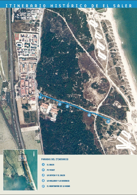
The name “El Saler” probably refers to a group of thatched houses (called barracas) that were located where the village now is and which were used to store the salt that came from the old salterns near the area known today as “Racó de l’Olla”. The growth in population around these barracas, seems to have been the origin of the village of El Saler.
Other types of building began to appear next to the nucleus of barracas. At the end of the 18th century the “Casa de la Demanà” (The Request House), and the “Casa de los Infantes” (The Princes’ House) were built. The latter, which no longer exists and which was opposite the former, was a hunting lodge for visiting royalty.
In the “Casa de la Demanà” also known as the “Casa de la Cam¬paneta” (the Bluebell House), auctions were held for licenses to hunt in the Albufera until approximately half way through the last century. Although it was remodelled at the start of the 20th century, the original curved bars that enclose the small balconies and the windows adorned with “coping”, or “hats”, that are also curved, remain from the original construction..
Currently the right to use the Casa de la Demanà has been transferred by the owners to the “Friends of the Casa Demanà” Youth Association and the El Saler Falla (a neighbour’s association that organises the festivities for the Fallas festival in March).
Within the grounds of the Luis de Santangel state school there is a magnificent example of the Stone Pine (Pinus pinea), a species of pine that is not very common in the Devesa.
The local Valencian name, pi verot, can be translated into Spanish as “large true (verdaderote) pine”. The adjective “true” (verdadero) is used because it belongs to the only species of all the pines that produces pine nuts, and the suffix “-ote”, meaning large, refers to its unusual size.
Its trunk is robust and short, and the branches form an umbrella shaped canopy that casts a shadow on the ground of approximately 440 square metres at midday.
It is about 14.5 metres high and its circumference at the base is about 5 metres. It is estimated to be about 175 years old.
The inhabitants of the village of El Saler have traditionally made use of many of the natural resources that the Devesa woods provide. Among others we can highlight the use of Butcher’s Broom for cuttlefish fishing, the use of branches of the White Rockrose to protect the sick and dying from evil spirits, the use of Myrtle and Mastic branches to make carpets to decorate the streets for processions and festivals, the use of Glasswort ashes to make soap, the root of the Yellow Lily to find and keep love, and the use of the wood of different bushes, above all the Palestine Buckthorn, as fuel for ovens.
From this point we can see the El Saler dune slack. Some of the materials used to build the traditional living quarters in this area, the barraca, were obtained from the dune slacks.
The dune slacks are depressions that, since they have a muddy clay soil, flood when it rains. Cord-grass (Spartina versicolor), the plant which is traditionally used to thatch the roofs of barracas, grows at their edges and in the less salty areas. Tuff, which was used to make the floors of these houses, was found in the soil of the dune slacks..
The “Cubano”and “Montoliu” barracas, and the “Barraca del Cotero”, also called the “Barraca de la Tía Rosario”, were famous in El Saler. The last two, decorated with original antique furniture, attracted large numbers of visitors.
The “Montoliu” barracas , which were destroyed at the end of the 60s, were located in what is now Avenida de los Pinares (Avenue of the Pines), approximately on the site of number 12. The barraca of “la Tía Rosario”, which was built in the 18th century, was destroyed in 1998.
Around this point is an area which has been used for leisure for many years, called the Muntanyar de la Mona. It name is possibly related to the tradition of the “Mona de Pascua” (Easter bun). This area of open scrubland, near the sea, with shade and close to the village made it an ideal place to go to eat the “mona” (this is a deeply rooted tradition in which on Easter Monday families and groups of friends eat the “mona” together in the afternoon).
The “mona” is a bun made of a spongy dough, which is accompanied by a hardboiled egg, which is usually cracked open against the forehead of a friend or relative, before it is peeled and eaten.
The word “mona” comes from the Arab word “munna” and means gift. In the 18th century it was the classic gift from a godfather to his godchildren. The number of eggs that accompanied the bun corresponded to the age of the child. This was done until they were 12 years old.
Nature provides us with all sorts of clues that can be extremely useful when interpreted correctly.
A little to the right here, we found the trunk of a Devesa pine tree that died in a fire in 2005. Its concentric circles allowed us to date events in Devesa and provided us with data on the prevailing conditions during the region’s development.
The thicker rings indicate favorable living conditions at the time, while the narrower rings reveal a more adverse environment due to things like droughts, pests, frost, fires, and diseases...
Did you know that analyzing the rings in the trunks of the oldest Spanish trees has allowed us to determine what the climate of the Peninsula was like many centuries ago? Did you know that these rings can educate us about our past?
A tree’s uneven growth indicates its orientation, with the thickest part receiving the most sunlight, thus pointing towards the south.
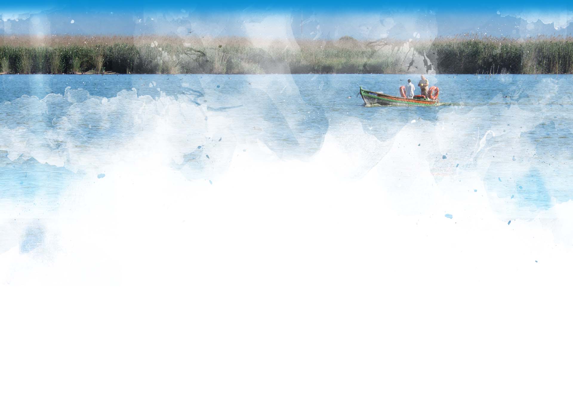
Look around you. The Gola del Pujol channel was constructed right here in 1953.
The Albufera Natural Park wetlands currently connect to the ocean through five channels. Three of these (Gola de El Pujol, El Perellonet, and El Perelló) connect the l'Albufera Lake with the sea, while the other two (Gola del Rei/Mareny and Sant Llorenç/Cano de Cullera) drain the waters of the Sueca and Cullera marsh.
Of the three channels that connect the lake with the sea, Pujol is the only one that does so directly because the others connect through a network of channels. This particular channel is about 1km long and 45 meters wide.
It has 11 lockgates to prevent salt water from entering into the lake during a storm, and regulates the water level of the lake using an adjustable weight placed in one of the cutwater.
In 1990, a system of motor pumps was installed to drain the lake after a storm when the state of the ocean won’t allow gravity to drain it naturally.
These golas are natural or artificial channels that connect the lake of l'Albufera with the sea.
Until the beginning of the 18th century, there was only one natural gola over 200 meters wide. It was opened and closed with a reed and mud barrier in order to control the flow of fish between the sea and l'Albufera, as well as the water level.
The amount of fresh water increased due to irrigation development and the natural channels’s closure from excess sediment. At The beginning of the 17th century, this caused the Albufera to become a freshwater lake, which resulted in the salt mines abandonment, a reduction in fishing, and the expansion of nearby rice fields.
While the lake still had a high enough salinity level, a few Racó de l'Olla salt mines, which were likely of Roman origin, would continue working in the Albufera to supply salt to the city of Valencia.
The higher proportion of fresh water in the lake led to the construction of new channels to ensure the surrounding rice fields could be properly drained. At the end of the 18th century, the current Perelló channel was excavated. The Perelló River was constructed in 1873, and the Pujol later in 1953.
Several species of fish reproduce in the sea and later come to the Albufera to feed. One of them is the elver, which will later grow into a full-sized eel. Elvers are currently being fished in the waters of Pujol, although that wasn’t always the case. Their commercialization began in 1925 when Basque steelworkers came here from the blast furnaces of Sagunto, and their regulation began in 1936.
The eels come from the sea and swim along the shores of the channel towards l'Albufera. They avoid the light, so it’s best to fish for them on dark nights when the water is calm. These days, they’re caught with a trap that is usually set on the southern bank of the channel in the stretch between the lock-gates and the sea.
Rice fields occupy around 70% of the total surface area of the protected region, creating a beautiful landscape throughout the year. Harvesting rice is the primary economic activity of the territory and constitutes a vital habitat for waterfowl to feed.
Throughout the year, the landscapes of the rice field vary depending on the water level.
Although it may not seem like it at first, if we look closely we will discover the presence of an interesting array of avifauna along the route. The dense vegetation of the Devesa contains a large number of insects, fruits and seeds that several species of bird feed on, especially the small birds that we can detect and identify through ther song. Thus, a little expertise will allow us to discover an abundance of black-headed warblers, common blackbirds, great tits and European serins throughout the year, as well as European robins and Eurasian blackcaps during the winter season.
On the shores of the channel may be little egrets, gray herons, and common kingfishers who come to stalk the smaller fish. Many of the birds that breed in l'Albufera come looking for food in spring and summer, so we’re able to find common terns, little terns, black-headed gulls, and slender-build gulls along the channel, as well as sandwich terns and Audouin’s gulls closer to the sea.
In autumn and winter, Palmar fishermen set up their gear at the entrance of the channel which makes it possible for birds like the great cormorant as well as seagulls and ferns to stand on a wooden pole and dry their feathers after diving into the l'Albufera.
The local name Pujol means mound or hill and undoubtedly refers to the regions tall dunes. If we look towards the northern section of the channel near the sea, we can see the Muntanyar del Pujol, which is one of the highest dunes in Devesa. This 9.5 m dune was saved from certain devastation when the Devesa Urbanization Project was implemented in 1965. These days, it still stands as an example of a first-line dune ecosystem in Devesa, and is classified as a Reserve for its significant geomorphological and botanical interest.
Also from this spot, if we look to the south, we can see the Estany del Pujol. This artificial lake was excavated as part of the 1965 Urbanization Project of the Devesa to create a recreational marina connected to the ocean through the Gola del Pujol. The space evolved naturally when construction stopped, and it currently houses species of flora and fauna that are typical of the Mediterranean coastal saltwater lagoons and are of great value and interest. Many species of migratory birds use the lake to rest and feed.
The Estany del Pujol is an artificial lake that was excavated during the Devesa urbanization of 1965. The purpose was to build a marina for recreational boats that could sail towards the sea through the channel that connects the ocean to the lake. After the urbanization project stopped, it quickly evolved into a natural site and now houses several species of fauna and flora of great value and interest.
It has an approximate surface of 10 hectares. The saltwater lake has an uneven surface at the bottom, and two types of banks; one smooth and the other more pronounced.
The wind combined with the plankton and mineral salts in the water can form a dense layer of foam on its banks.
The space is inhabited by species that are typical of the Mediterranean salt marshes. Types of flora include the Arthrocnemum macrostachyum, the salsola, Juncaceae, as well as different species of Limonium.
Its avifauna is also of great interest. Here the birds can find a tranquil spot to feed, rest, and nest. It’s used by many species of birdlife during their migration, including the curlew sandpiper (Calidris ferruginea) that breeds in the tundra of the Arctic.
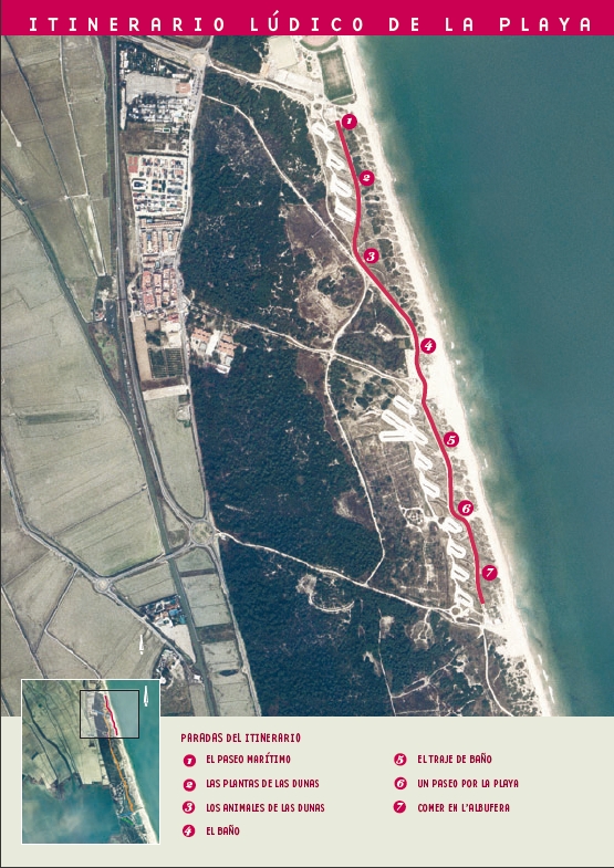
The old ecosystem of the fore dunes that characterized the El Saler beach was destroyed at the end of the 60s to construct a beach promenade which was raised above sea level, with restaurants and showers underneath. This promenade was eliminated at the start of the 90s and was replaced by a line of dunes and the current promenade along which this route runs. The new promenade, as it is at sea level and located behind the dunes, has a lesser impact.
Since before the middle of the last century the beach of the Devesa has suffered a process of heavy erosion caused by the lack of new sand reaching the beach, which was in turn caused by the regulation of river levels and the barrier effect of the port of Valencia. This situation was aggravated by the presence of the old promenade which also caused erosion (the El Saler beach is so narrow that the promenade worked as an obstacle, and during storms the energy of the waves would multiply when they crashed against it, and therefore carry more sand away as the water returned to the sea). There is now beach where the promenade used to be.
The artificial construction of a new line of dunes in front of the promenade was carried out because of the vital role that the dunes play in stabilizing the beach. On the one hand they act as a reserve of sand that preserves the beaches in front of them and maintains their equilibrium, and on the other, they protect the vegetation growing behind them from the sea winds. The particular characteristics of the plants and animals that live in these dunes, which are adapted to very harsh environmental conditions, give them a unique natural value which increases if we take into account that nowadays this is a very rare ecosystem due to the massive urban development along the coast.
At this point the promenade moves away from the sea and runs behind an area of dunes that was not destroyed when the old raised promenade was built. The plants that can be seen are those that correspond to the characteristic scrubland of inland dunes. These plants are unable to bear the sea wind directly and they therefore grow as creepers, never growing higher than the dunes in front of them that protect them. We can see Mediterranean Fan Palms, Mastics, Sarsaparilla and even pines. All adopt the form of small cushions, as if “combed” by the wind. If we look carefully at the pine we can see that it grows laterally rather than vertically.
As we move to look at the fore dunes we can see that there the forms of the plants are different. They are all adapted to survive in this environment. They are able to resist the strong sunlight, the continual beating of the salt wind and the constant mobility of the sand which often covers them, and blocks their photosynthesis, or reveals them completely, leaving their roots in the air. We can observe that their leaves are small, and in this way they avoid dehydration as far as possible, or they are a whitish colour because they are covered with small hairs that protect them better form the environment, or they are fleshy which allows them to store water in their interior. Look at the leaves of the European Marram Grass, which are rolled around on themselves to avoid evaporation.
The stalks of all these plants grow along the ground to minimize the effects of the wind, or they grow vertically and are flexible and strong so that they can bend without breaking. All their roots are extremely long so that they are well anchored in the sand. It is important to bear in mind that not all plants can live in an environment with such harsh conditions.
Like the plants that live in the fore dunes, the way of life and the mechanisms of adaptation of the animals that live here are conditioned by the environmental characteristics of the ecosystem. The lack of shade, and the excessive temperatures that the surface layer of sand reaches during the day, and the extreme temperature differences between the day and the night, mean that many of the animals in this environment, as in the case of some beetles, exhibit twilight and nocturnal rhythms of biological activity: they remain buried in the sand during the day and come out at dusk to find prey.
The species of snail that live in these dunes are also adapted to the environment, with thick shells and a high resistance to desiccation. To avoid contact with the ground at times of maximum solar radiation they climb up onto the branches of plants during the day and stay immobile there until the night comes, when they come down to feed (the high temperatures on the ground, in summer, could literally cook them).
The softness of the sand, which makes it easy for some species to bury themselves, also means that some of the animals that live in this environment have developed special appendicular structures that help them to walk over it better. The Red-tailed Spiny-footed Lizard has a kind of scales on both its front and back feet that allow it to run very fast over the sand without sinking.
If we walk this route in summer and we look towards the beach we will see families, couples and groups of friends bathing or sunbathing. Though this seems very normal now it has not always been like this.
The fashion for bathing in the sea began at the end of the 18th century and the pioneers were the aristocrats in the south of England. During the 19th century the practice of sea bathing became increasingly popular. The doctors of the period took up the idea, which the ancient Egyptians, Greeks and Romans had already advocated, of the curative effects of seawater, and recommended sea bathing as a way of preventing and curing numerous health problems and diseases. People began to go to the beach.
From the middle of the 19th century to the start of the 20th century the bathing areas were segregated by sex: one part of the beach was reserved for women and another for men. Men were prohibited from walking on the beaches reserved for women while they were bathing
At the start of the 20th century, bathing in the sea began to be appreciated not only for its curative qualities but also as a way of resting and relaxing. The “rope bathing system”, a practice which consisted of bathing while holding on to a rope that was tied to posts set in the sand, testifies to the collective nature of the activity. This was a practice used especially by old people and those who felt uncertain about going into the sea. Halfway through the last century, and coinciding with longer holiday periods, the popularity of bathing led to a great number of people coming to the beaches. One went to the beach simply for pleasure, rather than to cure an ailment.
The bathing suit has changed considerably over time. The first female bathing suits which appeared at the start of the 19th century were made of flannel, dark coloured, and composed of a close fitting body with a high neck, and sleeves to the elbow, a skirt to the knees with trousers underneath, black stockings and canvas shoes. At the end of the 19th century this bathing dress was simplified and replaced by a long shirt, trousers and socks. Dark colours were replaced by lighter ones.
25 years later socks were no longer used for bathing, and men were able to use shorts but women still used long shirts and skirts. It was in the 30s of the last century that the female bathing suit appeared. It was made of wool and had a vest and short trouser that covered the thighs.
In 1946, a Frenchman called Louis Réard presented a two piece bathing suit. He called it the bikini, like the Pacific atoll where nuclear tests were being carried out that year. This suit was so daring that the person who modelled the suit at its presentation compared the effect it would have on society with the reactions to the nuclear tests on those islands in the newspapers of the time. The use of this kind of bathing suit did not become popular until the 60s. Its arrival in Spain coincided with the tourist boom of the end of that decade. The first elastic bathing suits, like those that are currently used, appeared in 1960, the year in which Lycra was invented.
The bathing huts in which people changed their clothes have also changed over the last two centuries. At first they were mobile with wheels: they were used to move the bather close to the sea, and even had a ramp which was used in order to slide into the water. The aim was to preserve the bather from the view of others and maintain decency. They were also used to facilitate access to the sea for sick people who needed treatment. Until the 70s of the last century it was normal to see the beaches covered with wooden bathing huts, usually striped, which could be hired and were used to change clothes. These huts are no longer part of the beach landscape.
Going down to the water’s edge we will see that a simple walk along the beach can become an interesting adventure of observation. A walk after a storm is a perfect moment since the sea bed has been stirred up and the material dragged up by the waves is much more diverse and may come from further away. What we see can give us an idea of the life a few metres below the water, although we also find other objects that remind us that the sea returns to man whatever he throws into it.
On the sand we can find a wide variety of mollusc shells of different forms, sizes and colours, snail shells, the remains of skeletons, such as those of the cuttlefish, shark eggs such as those of the cat shark, seaweed, crabs, starfish, balls of Posidonia leaves, “bunches of black grapes” which are simply eggs that have come loose from the rocks on the seabed, small pieces of coloured glass with different degrees of polish depending on the time they have been exposed to the erosion of the sea, remains of old pots, octopus hooks...
If we look closely we will also find different animal tracks in the sand and the muddy area closest to the sea, above all of birds. We can find the tracks of gulls, of the Kentish Plover, or of terns… In the dune area we can find the tracks of the Dung Beetle, the Red-tailed Spiny-footed Lizard or the Large Psammodromus, herons…
The Albufera Natural Park is and has been the natural habitat of two of the elements that have most characterized and influenced Valencian cooking: rice and eels. As well as these two elements, the closeness to the sea, and the variety of fresh vegetables, the product of the large number of market gardens along the coastal strip, make up the classical ingredients of the cooking of the Albufera.
The most typical dishes of the area are paella and all-i-pebre. Paella and rice have many variants in the Albufera such as the cod and vegetable paella, duck paella, arroz a banda (rice with fish), arroz negro (rice cooked with squid ink), rice with cabbage and eels, rice with greens and snails, arroz “amb fesols i naps”(rice with turnips and peas)…
All-i-pebre is the most native dish to this area, it is really the name that is given to the sauce that accompanies certain fish and meat dishes and which uses a base of fried garlic and paprika. The inhabitants of the area have usually used eel as the main ingredient and this fish has become a vital component that is usually associated with this dish.
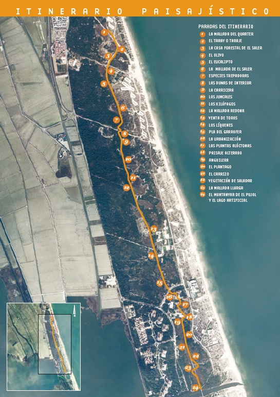
From here we can see the dune slack known as the Quarter. The dune slacks are interdune depressions located among the pines, where muddy ground predominates. This ground is grey and impermeable, and this means that in the rainy season, mainly in autumn, pools develop and then dry out in the hot season by evaporation which leads to a gradual salinization of the ground.
Man has used different techniques to avoid the formation of pools in the dune slacks of the Devesa, and this has caused grave alterations to this singular ecosystem. In particular the Quarter dune slack was filled with sand from the fore dunes during the urban development process that was suffered by the Devesa at the end of the 1960s. Fortunately, in 1999, the dune slack was recovered and returned to its original state.
The French Tamarisk (Tamarix gallica Webb), which is called Taray, Taraje, Gatell or Tamarit in the area, is a small tree or shrub of 6 to 8 metres high, with thin, flexible branches, characterized by their light feathery aspect. The glaucous green leaves are very small and hug the branches. The small flowers are white or pink and form dense bunches on the branches. They appear at the same time as the leaves between the months of April and June.
Normally, it can be found in areas close to water channels, saline depressions and coastal sand, although its ideal habitat is on the edges of fairly salty dune slacks.
The El Saler Forestry Protection Centre was built in 1920 and currently is the headquarters of the forestry officers and the local police.
The presence of this Olive tree and others, as well as other specimens such as Fig and Carob around the Devesa, demonstrate the existence of crops in the area in the past.
The Olive is a typically Mediterranean species that is adapted to the climate of the area, and is present in the landscapes of the Iberian Peninsula as one more element of Mediterranean ecosystems and culture.
At the start of the 20th century, with the aim of drying out the malflecoladas (flooded areas) of the Devesa, the Eucalyptus was introduced; this is an allocthonous species from Australia that is capable of resisting temporary flooding, grows fast and needs a large amount of water. Furthermore as can be seen here, it was also used as an ornamental tree.
The Eucalyptus is a species that causes important damage to the ecosystems into which it is introduced because it competes at an advantage with the autochthonous vegetation for the water and nutrients in the ground, and because its leaves exude substances that impede the germination of other species.
The low lying area we see here is called the El Saler dune slack. The vegetation that grows in dune slacks is distributed in concentric circles, which depend on the salinity and the composition of the soil. In the centre of the depression the soil is bare due to the concentration of salts, and it cracks in the summer due to the drying out of the mud.
The plant community which grows closest to the centre is made up of herbaceous annual succulent species that give it a reddish look in autumn; species such as Salicornia emerus and Suaeda marítima are particularly important. Around the previous group, or replacing it, is a community of more robust perennials, which form isolated groups in the bare soil. Species such as Sarcocornia fruticosa and Arthrocnemum macrostachyum dominate. In the more outlying circles there are communities of rushes, sedges, grasses and plantains that prefer less saline and moister soil and form dense meadows.
In this landscape the Sarsaparilla stands out (Smilax aspera L.), this is a creeper which climbs shrubs and the naked trunks of trees to reach the light it needs for photosynthesis.
Other creepers and lianas we will see on this route climbing up trees and shrubs are the Honeysuckle (Lonicera implexa Air.) and the Fragrant Virgin’s Bower (Clematis flammula L.).
This is the internal dune system, the oldest in the Devesa. In this ecosystem the coastal maquia grows, this is the most evolved plant community in the Devesa, made up of a much more complex vegetation with a tree layer principally made up of Aleppo Pine, a shrub layer of great diversity and wide cover, with species such as False Olive, mastic, Myrtle, Palestine Buckthorn and a wide range of herbaceous and subarbustive species.
The Plume Grass (Erianthus ravennae (L) Beauv.), also known here as the cesguera, is a reed of medium height, which grows in moderately wet depressions. It flowers in autumn with dramatic feathery plumes.
As a curiosity it is worth mentioning that the stem of this plant is used in pyrotechnics to fire rockets, since it is hollow.
Rush beds are common in less saline dune slacks with a certain degree of moisture. From this point we can see two types of reed, Juncus acutus L. and Juncus maritimus L., both of which have pointed leaves, but can be distinguished easily because the first has more compact groups of flowers.
Another species we can see from here is Scirpus holoschoenus L., which is identifiable because its flowers are grouped in brown spheres.
Here we see a tree trunk that is being decomposed by xylophage insects and fungi that have their home and their source of nutrition in the wood. It is worth indicating that some xylophage insects can be identified due to the type of perforation they make in the wood.
From here we can see the Redona dune slack, one of the many depressions that were altered with the intention of drying them out, using different systems. The oldest system for which there are references consisted of digging a network of small canals known locally as “anguileras”, which allowed the water to flow from the dune slacks to the sea. Later, plantations of Eucalyptus were used.
Just before the initiation of the Devesa urban development project, the technique used was to dig a series of parallel ditches through the dune slack that broke the impermeable layer and allowed it to drain. Then, during the urban development process itself the strategy was to fill almost all the dune slacks with sand from the fore dunes and some were even built over, with roads or buildings. As can be seen, the Redona dune slack is currently filled in, with a strong imbalance in the plant community.
From here we can see the Venta de Toros, a facility that belongs to the Provincial Government of Valencia, and which is sometimes used to house the bulls used for the bullfights in the city.
The lichens that can be seen on the trunks and branches of these Tamarisks and Mastic, are called epiphytes. They are characterized by the fact that they do not grow on the ground but on some kind of substrate such as a tree trunk, rocks or even walls, and depend totally on the nutrients that are transported by the air.
These lichens are used as indicators of the quality of the air, since they are very sensitive to atmospheric pollution. When the levels of pollution rise they tend to disappear.
In 1980 in this area, known as the Pla del Garrofer, there was a great fire. Soon the first regrowth and germination took place, mostly of fire-favoured species as in other fire damaged areas. Species such as the Kermes Oak and the Mediterranean Fan Palm quickly re-sprouted, and Pine and Rockrose germinated too.
Nowadays we can see that the process of natural regeneration, without any kind of human intervention, is proving successful.
At the end of the 60s a process of urban development that seriously altered the three existing ecosystems of the Devesa began. The fore dunes were destroyed almost completely and replaced by a sea promenade, the dune slacks were filled in with sand from the seaward dunes and the inland dune system was broken up by the construction of buildings, roads, and hydraulic and electric infrastructure, as can be seen from this point.
The devastation was so obvious that it produced a very strong response from the citizens, who with the help of university and conservation groups managed to stop the urban development at the end of the 1970s.
The buildings we can see here, evidence of the urban development process, have gardens with a wider range of allocthonous species which we will see from here to the next stop.
Before us is a plant called the Century Plant or Maguey (Agave americana L.) which is originally from Mexico. It is known for flowering only once in its life, after 10-15 years, in summer. It produces a large stalk, up to 10 metres high, at the top of which are the flowers. After flowering, the plant dies.
Next we see the Ice Plant (Carpobrotus sp.), a plant that is originally from South Africa. It is characterized by its tendency to cover the ground it inhabits very rapidly, which is a danger for autochthonous vegetation. On the right of the route we can see hedges with two allocthonous species, the Pittosporum and the Myoporum, which are frequently used in gardening.
From this point we can get an idea of what the Devesa would look like now if the urban development process had not been stopped. There would be luxury hotels like the Sidi Saler, semi-detached housing, a multitude of buildings with gardens and allocthonous species, an extensive road network with parking areas such as those in front of us, and a permanent population of more than 40,000 people.
The oldest known system for drying out dune slacks consisted of a network of small canals known locally as “anguileras”, which allowed water to flow from these depressions to the sea. On the right of the path we can see an old “anguilera”. The name “anguilera” is due to the fact that eels (anguila in Spanish), which were very abundant until the 1960s, used this network of canals to move between the sea and the Albufera lagoon.
In this depression which is very wet with low salinity there are communities of rushes, sedges, grasses and plantains. The presence on both sides of the route of Plantago crassifolia Forsk is worth noting. This plant lives on the edges of depressions and forms fairly dense lawns which can be distinguished by their linear, fleshy, semi cylindrical leaves, which sometimes have serrated edges.
On the right of the path we can see Marram Grass. This perennial plant, which grows in temperate regions, can be found in wet soils, shallow water, wetlands and rivers. It is characterized by its tall slender stalk covered with long wide leaves.
It flowers at the end of summer and in autumn, and forms dramatic plumes at the top of the stalk.
Marram Grass, together with other grasses has been for a long time a raw material for many domestic applications, since it was available for anyone to use.
To the left of the path we can see two species that are normally found in depressions with wet and strongly saline clay soil. These are the Glasswort (Sarcocornia fructicosa (L.) A. J. Scott) and the Glaucous Glasswort (Arthrocnemum macrostachyum (Moric.) Moris). They are small shrubs, with fleshy articulated stalks, and leaves that are no more than small scales.
These plants are easy to confuse, we can recognize them because the flowers of the glaucous glasswort appear on young branches, and therefore appear at the top of the plant, while the flowers of the glasswort appear inside the plant.
Nearby we can also see a plant that is characteristic of saline soils that are not continuously flooded, the well known Sea Lavender (Limonium sp).
The interdune depression we see here is known as the Llarga dune slack. It was recovered in 2004. The regeneration consisted of using an excavator to remove the sand that covered the dune slack down to the impermeable layer of grey mud that characterizes this ecosystem. Later the perimeter of the dune slack was remodelled with soft slopes, with the object of providing easy access for avian fauna.
From this point we can see the Muntanyar del Pujol, which together with the Muntanyar de la Rambla were the only fore dune ecosystems that were saved from the urban development process. From 1984 these areas have been closed to the public due to their great ecological value. From here we can also see the well-known artificial lake which was constructed during the urban development process over a large depression, and was intended to be the start of a future yachting marina.